The Dutch East India Company did not come to Ceylon to paint it. For a century and a half, from the first fleets of 1602 to the surrender of the maritime provinces in 1796, the Verenigde Oost-Indische Compagnie (VOC) held the coast as a commercial possession, a territory to be charted, guarded and administered, and the images it made of the island were made to serve that end: to map a reef, to site a bastion, to record an embassy, to fix the plan of a fort so that Amsterdam might know what it owned. What they left is an archive before it is an art, a body of maps, ground-plans, coastal profiles and town views drawn for use, and its character, measured and plain and informational, follows from that purpose. It became art with age, as working things do.
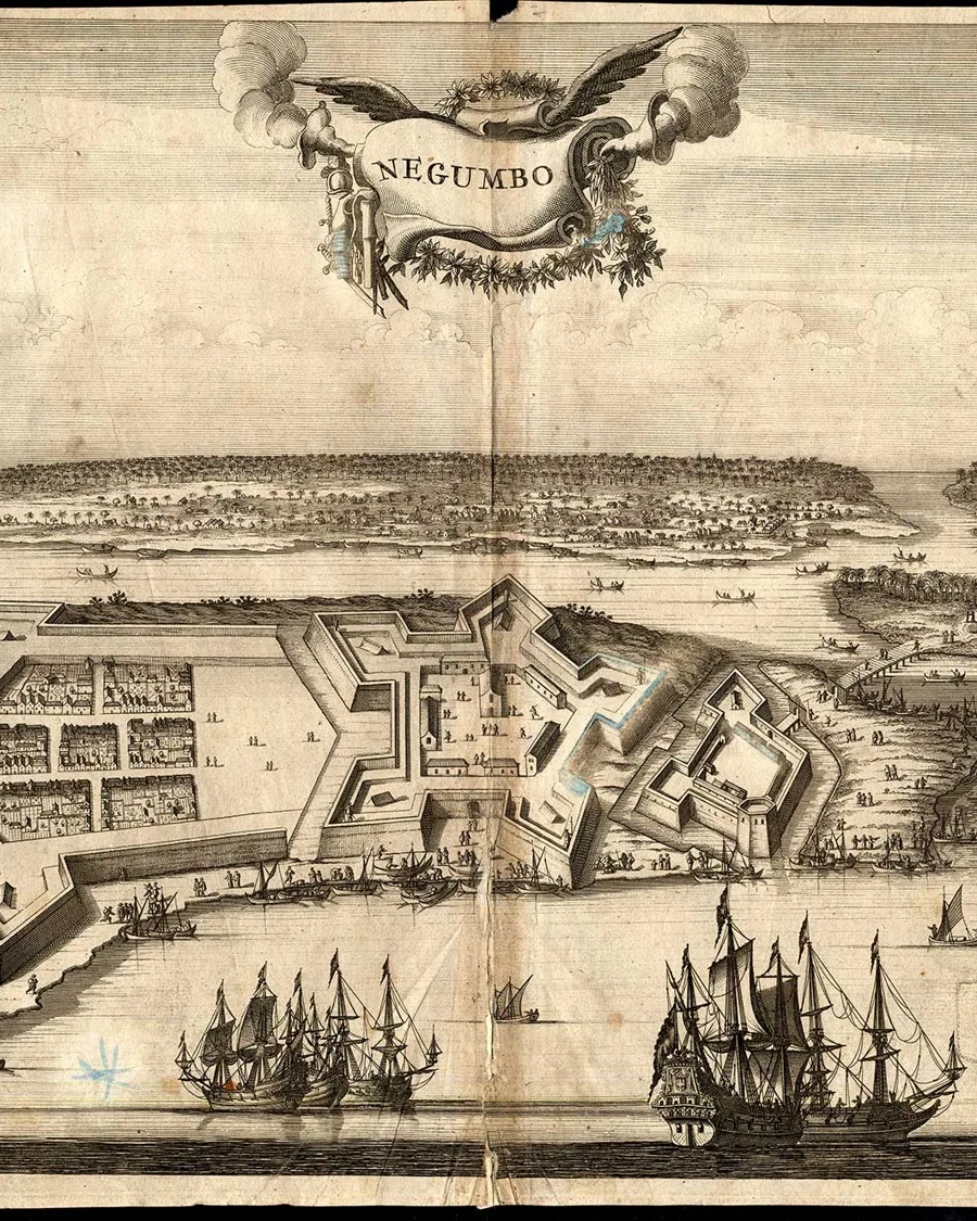
The kinds are few and clear. First is the map and the fort ground-plan, the surveyor's daily work, on which the whole administration of the coast depended. Then the coastal profile and the town view, the settlement taken broadside from the roadstead so that ramparts, church towers, shipping and shore read in one long band, the sight of a sea power that knew its harbours first from the water. Beside these ran the illustrated travel account, the folio in which a returned traveller set his eastern years before a Dutch public, its plates gathering war and ceremony, costume and custom, the strange fruit and the stranger beast. At the very last came the natural-history watercolour, exact and patient, made to record a species rather than a scene.
The hands
Most of the men who made this record were not painters by trade, and the section names each for what he was. The first came with the very first fleet: Cornelis Jansz Vennip, who sailed with Admiral Joris van Spilbergen to the court of Kandy in 1602 and is thought to have brought back the sketch of the town and palace, and the portrait of King Vimala Dharma Suriya, that were cut into the fourteen plates of Spilbergen's Historiael Journael. There were surveyors, Adriaen de Leeuw drawing Galle and Colombo in 1659, Cornelis Steiger with his coloured views of the forts about 1710, Balthasar van Lier mapping the island a generation on. There were soldiers who had learned to draw, the Bernese Albrecht Herport, the German Johann Jacob Saar. Inland, Arent Jansen was sent by Governor van Domburg to record Mulgirigala, taking impressions of its rock inscriptions through paper laid over soot, his drawings engraved for Johann Wolfgang Heydt's topographical folio of 1744. There was a ship's surgeon, Wouter Schouten, sketching the ports between engagements; there were ministers of the Reformed Church who compiled more than they drew, Philippus Baldaeus in the north and François Valentijn in his vast folios; there was a traveller-painter passing through, Cornelis de Bruyn. The one great exception stands at the close. Pieter Cornelis de Bevere, Ceylonese and Company-trained, made for Governor Joan Gideon Loten, the 'naturalist' Governor and a Fellow of the Royal Society, the finest single body of painting the island produced under Dutch rule; Loten's Ceylon watercolours were afterwards engraved for the zoologies of Thomas Pennant and Peter Brown, the point at which the island's record entered European science, and in de Bevere's hand the island's own eye enters that record for the first time. Latest of all, and with a reporter's eye for ceremony, came Jan Brandes, who at the Governor's residence drew the audience given to the ambassadors of the King of Kandy, and near Jaela set down a series of captioned watercolours of the trapping and taming of wild elephants.
The engraver's hand
Between the drawing made in Ceylon and the plate seen in Europe stood the Amsterdam print house, and it left its mark on nearly everything. The greatest of these houses was Jacob van Meurs, the leading publisher of the wider world in the years around 1670, whose lavish folios on China, Africa and Japan, made with Johan Nieuhof, Olfert Dapper and Arnoldus Montanus, set the fashion for the illustrated travel book and the ornate manner that went with it. Van Meurs printed Schouten's voyage, its Ceylon views cut on copper by Coenraet Decker and Jan Kip; the van Waesberge press printed Baldaeus; the maps came from the houses of Blaeu and van Keulen. The plates of such books were said to be drawn from life, and in a measure they were, yet the print-makers of the studio finished and embellished them for the market, so that a low coastal fort could take on a stateliness the ground never had. To read these plates well is to read two hands in nearly every one, the eye that saw and the burin that dressed it, and the Hindu deities in Baldaeus are a plain case of the same doubling, carried over less from any temple than from an earlier book, the 'Open-Deure' of Abraham Rogerius. The natural-history watercolours of de Bevere are the great exception, for they never passed through a print house at all, and keep to the end the directness that engraving took away.
One last thing shaped the record, and that was secrecy. The Company bound its servants by oath to surrender every map, log and journal, and kept an official Cartographer at East India House in Amsterdam to hold the knowledge close, so that much of what survives is anonymous, the work of draughtsmen whose names went unkept even as their sightlines were preserved. When the British came in 1796 and the picturesque draughtsman followed, seeking the island for its beauty, he inherited a coast the Dutch had already measured. The distance between the two records, the one made to hold the island and the other to admire it, is the distance between two empires' idea of what a view was for.
Sources
- R.K. de Silva and W.G.M. Beumer, Illustrations and Views of Dutch Ceylon 1602–1796, 1988.
- Philippus Baldaeus, Naauwkeurige beschryvinge van Malabar en Choromandel ... en het machtige eyland Ceylon, Amsterdam, 1672, and his debt to Abraham Rogerius, De Open-Deure tot het verborgen Heydendom, Leiden, 1651.
- Joris van Spilbergen, 't Historiael Journael, Delft, 1605, with the plates of Balthasar Floris van Berckenrode, and recent scholarship on the first Dutch embassy to Kandy ('Candy is Now Flanders: Mapping Dutch Identity in the First Dutch Envoy to Ceylon').
- Wouter Schouten, Oost-Indische Voyagie, Amsterdam, 1676, its plates engraved by Coenraet Decker and Jan Kip for the press of Jacob van Meurs, the Amsterdam house that also published Johan Nieuhof and Olfert Dapper.
- François Valentijn, Oud en Nieuw Oost-Indiën, Dordrecht and Amsterdam, 1724–1726 (the account of Ceylon in the fifth volume).
- The Atlas of Mutual Heritage (Nationaal Archief, The Hague) and the Rijksmuseum, Amsterdam, for the maps, views and object records of VOC-period Ceylon.
How to cite this essay
Malaka Talwatte, “The Dutch Record: An Island Drawn for a Trading Empire, 1602–1796,” Malaka Talwatte: Sri Lankan Art and Ceylon Antiquaria, https://malakatalwatte.pages.dev/publications/dutch-record/.
Quote and cite freely with attribution; please do not republish a whole essay, or a photograph, without permission.